Saskatoon Neighbourhood – Holiday Park
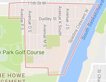

Layout – The northern boundary extends no further than 11th Street, and the southern edge overlooks the scenic vista of the Holiday Park Golf Course. Avenue P South through to the South Saskatchewan River are the western and eastern boundaries respectively. The roads are laid out in a grid fashion, the streets south of 11th Street are named: Dudley, Shuyler, and Wellington Streets, followed by Embassy Drive. The avenues are labelled alphabetically with the alphabet. Spadina Crescent cruises along the South Saskatchewan River and incrementing westward through the alphabet. A key three-way intersection at 11th Street, Avenue H and Spadina Crescent has been closed for several years to allow for expansion of a water treatment plant, forcing southbound motorists to cut-through Holiday Park in order to access and egress Spadina.
History – The Saskatoon Tuberculosis Sanitorium was opened April 15, 1925.
June 27, 1962 was the officially opening of the Holiday Park Golf Course.
The Bowerman House was a hunting lodge constructed by Allen Bowerman, and later used as physician housing for The Saskatoon Sanatorium.
Education – Saskatoon French School / l’École Française de Saskatoon – elementary, associate school with Greater Saskatoon Catholic Schools.
St. John Community School – separate (Catholic) elementary, part of Greater Saskatoon Catholic Schools.
Area Parks – Boughton Park 6.07 acres (24,600 m2)
Holiday Park 8.62 acres (34,900 m2)
Victoria Park 4.98 acres (20,200 m2)
Shopping – There is local shopping available at the convenience stores located at Avenue L South and 11th Street such as a Lew’s Grocers, and White’s Pharmacy, as well the 11th Street arterial district begins at Avenue P South.
#AskSlade about properties currently for sale in this neighbourhood. Slade Real Estate Inc. 306-222-9992. sladerealestate.ca